1837 Antique Map of Malta & Italy
€ 150


Description
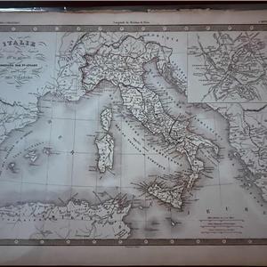
Original 19th-century French school atlas, by the cartographer François Ansart. Published in 1837, this atlas focuses on ancient and classical geography, including Roman Italy divided into the XI regions of Augustus, with ancient place names, road networks, and historical references.
All maps are copper engravings, printed in black ink on cream laid paper, with clear line work and visible plate marks. The atlas represents a fine example of early 19th-century cartography.
Details:
Title: Atlas à l’usage des collèges
Cartographer: François Ansart
Date: 1837
Technique: Copper engraving
Colour: Monochrome (uncoloured)
Language: French
Subject: Ancient / classical geography (Roman world). It depicts Roman era administrative divisions, not modern Italy.
Dimensions: 27 × 36.5cm (sheet size)
Item Details
10001246
27
Antiques
31/12/2025